

Data Collection
Collect millions of image and video data samples to train machine learning algorithms for drones & UAVs

Data Annotation
Train and power autonomous flight through our wide and effective range of sensor, image, and video annotation types

Data Evaluation
Perform incident triage and root cause estimation, as well as curate catalogs of 3D simulation and camera log-based scenarios

Deployment
Perform real-time monitoring and decision making services for development and production drone fleets
Services for Drones and Unmanned Aerial Vehicles

Data Collection
Capture and collect data to train drones according to technical, demographic, and timeline requirements

Image & Video Annotation
Annotate visual data with bounding boxes, polygons, cuboids, lines and splines, semantic segmentation, and more for image, video, and sensor data

Point Cloud Annotation
Use high-precision labeling tools to meticulously annotate point cloud data from a variety of sources, including cameras, LiDAR, and sensors
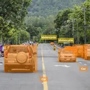
Object Detection & Tracking
Power drones with a solid ground truth, optimizing computer vision models for object recognition, tracking, movement prediction and more
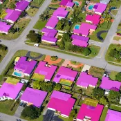
Aerial Imagery Mapping
Request quick and meticulous annotation services for aerial view imagery to produce high pixel mapping for enabling autonomous flying systems

Image & Video Annotation for Autonomous Vehicles
Learn how TaskUs optimized computer vision data annotation for a Leading Autonomous Vehicle Company:
- 1,800 full-time data annotators
- 16 project workflows, including semantic mapping, feature extraction, multilayer object classification, and LiDAR sensor fusion
- Custom-built quality framework, resulting in a 98% accuracy score
Our Awards
-
 Best CEO for Diversity -
Bryce Maddock, CEO, TaskUs -
 Best CEO for Women -
Bryce Maddock, CEO, TaskUs -
 Best Company for Career Growth
 -
 Best Leadership Teams
 -
 Top 50 Inspiring Workplaces list for
EMEA in 2022 (#27) -
 2022 Inspiring Workplaces Awards - EMEA (Finalist)


